Fern Canyon
Gold Bluffs Beach at the edge of Prairie Creek Redwoods

advertisement
The photo below shows part of Fern Canyon at the west edge of Prairie Creek Redwoods State Park in Northern California. Fern Canyon can be reached by hiking across the park on trails, or taking a road from Highway 101 to Gold Bluffs Beach. A small day use fee may be in effect. More information below.
Directions
Hiking: from the Prairie Creek Redwoods State Park Visitor Center off Drury Parkway, hike James Irvine Trail for about 4.7 miles.
Driving: taking Highway 101, about 2 miles north of Orick, turn west onto Davison Road. That turn is near a wide open grassy area signed for elk viewing. Continue west through the Elk Meadow, and shortly the grass gives way to forest. Continue about 6.5 miles to the parking and trailhead for Fern Canyon. Big RV motorhomes and trailers are not allowed on Davison Road. The parking and trailhead are about 1/4 mile from the Canyon.
The Drive from 101 to Fern Canyon Parking
When you turn from Hy. 101 onto Davison Road, the first scenery is a grassy meadow where Roosevelt Elk occassionally come to feed. After 1/2 mile, the meadow become forest, with a few young Coast Redwoods, and quite a few Spruce. The Spruce groves are quite attractive looking.
The road winds around corners for about 3 miles before you reach Gold Bluff Beach. Within that first 3 miles, keep an eye out for the Skunk Cabbage patches. In spring, they shoulc have yellow spathes which are pungent. The summer leaves are gigantic compared to any other leaves you will see around the Redwood or Spruce forests in the area. I measured some leaves at 62 inches. They are broad too, about 1 foot wide.
At the 3 mile point, the forest opens up to a view of the ocean. Moments later there is a small booth or Kiosk for registration. And after another 3.5 miles is the Fern Canyon parking.
There are 2 or 3 small creek crossings in the last 3 miles. Very shallow in summer: maybe 4 to 5 inches deep July through October. The creekbed is firm gravel so getting stuck should not be a problem for cars.
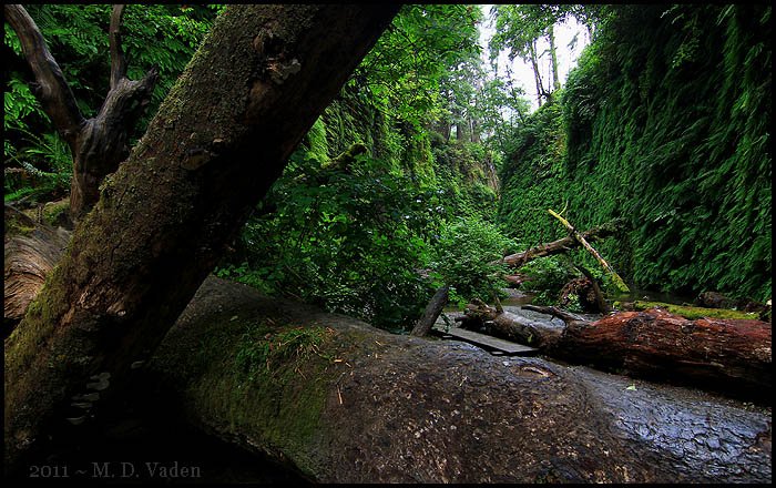
The trail quickly enters a grove of Alders, with light colored bark and patches of moss. The Alder makes a transition to a tiny river delta where the creek exits Fern Canyon out toward the Pacific Ocean. Shortly, the dirt trail meets the canyon and the gravel bed along the creek become the new trail. In summer months, planks have been set out to bridge parts of the creek.
Walls of the canyon are coated with ferns: upwards of 4 to 5 species. Fern Canyon walls can reach over 50 feet high. Using a laser, I got a reading of 70 feet in one area.
Eastward in the canyon, the trail leads up a hillside where you can get to James Irvine Trail.
You can also loop back above Fern Canyon. If you do, keep an eye out for a short unmarked spur trail that drops down to a tiny hidden meadow where Elk may be browsing or napping. If there are Elk, don't approach them. At least not closely.
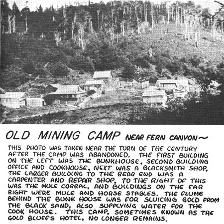
Formation of the canyon by mining
It is reported that Fern Canyon was formed or altered by hydraulic mining. I found at least one NPS document that said there was a mining camp right there adjacent to Fern Canon. The mining around this Gold Bluff beach area was in the late 1800 and early 1900's to extract gold.