Backpacking, hiking, 0vernight camping: Redwood National Park
Redwood Creek & Prairie Creek Redwoods at Miners Ridge and James Irvine Trails
by Mario D. Vaden

advertisement
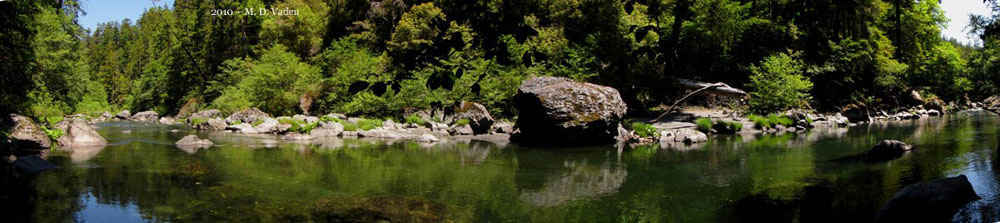
Header: upper Redwood Creek. 5 photos stitched. Water to 7' deep. Huge rock is about 20' wide.
Although there are a lot of hiking trails in the redwood parks, options for overnight backpack camping are not many. Hopefully these suggestions can help you if you are unfamiliar with the area. Be sure to check with the redwood parks information centers about your backpacking options, and any changes.
Visit redwoodhikes.com for each of the few trails mentioned below. Find the park, find the trail.
Two of the main areas we can go backpacking overnight are Redwood National Park and Prairie Creek Redwoods State Park. Prairie Creek has a camping area, but virtually all of Redwood National Park camping is along the gravel and sand bars of Redwood Creek. Basically anywhere you choose to pitch your tent or lay a pad and sleeping bag.
In Redwood National Park, the rules and area for camping include:
1. Upstream of Bond Creek to within 1/4 mile downstream of Tall Trees Grove
2. 1/4 mile upstream of Tall Trees Grove and continuing upstream about as far as you want
3. Borrow bear canisters for food, lock it up yourself, or suspend it sufficiently
4. No trace left behind
5. Campfires allowed near gravel bar and gathering of kindling around river okay
6. Camp permit required, with up to 5 days you can stay
One of the most popular trails in Redwood National Park is Redwood Creek Trail, but there are few large redwoods along that long trail. A good choice would be to begin with the Tall Trees Grove - TTG - trailhead. One big reason is parking behind a locked gate 7 miles in, instead of a vacant lot. That's a very comfortable place to leave a vehicle overnight or for several nights. If I was going to use Redwood Creek trail for an overnight, I'd have somebody drop me off at the parking area and a pickup rather than leave a vehicle overnight.
Summer and early Autumn between July 1st and October 15th offer the most alternatives and trail combinations.
The 1.3 mile trail to TTG is virtually a staple of a redwoods visit. Now what comes next? There are intermittent hot-spots for big redwoods and scenery downstream, even above Elam Creek horsecamp on a small off-shoot. If the Redwood Creek Trail were constructed higher uphill on either side, there would be a lot more big redwoods in view.
My choice after TTG would be to go back up TTG trail, and come back down on Emerald Ridge trail back to Redwood Creek. You can also walk upstream too, along the rock and gravel. The canopy of tall redwoods soars into the sky on both sides. Depending on time of day, you may see ducks flying, or river otters swimming.
Bring water shoes with thick soles if you plan to wade your way up the creek. Some people go up the edge of Redwood Creek as far as Bridge Creek to camp. Hardly anybody passes that point. If you have your water shoes and the creek is flowing slowly, consider going about another hour upstream past Bridge Creek. The look changes dramatically. The small river rock diminishes and eventually huge boulders appear and areas that look like nature's version of an Olympic swimming pool. There are numerous swimming holes up there.
The photo in the header above is part of Redwood Creek I'm referring too. You don't need to go quite that far, and there is hardly any way to get past that spot anyway. When we were there last, the water was flowing very, very slow, even though it was 5 feet deep in spots. But most of the way was dry rock and gravel or wading up to our shins. The deep crossings are minimal and easy.
But I'd say to aim for a half hour past Bridge Creek to amplify the wilderness feel.
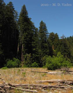
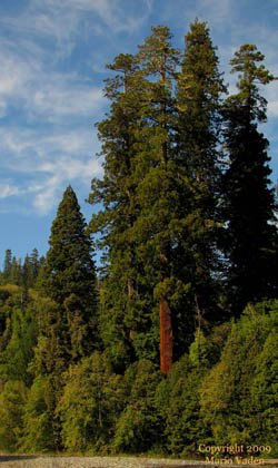
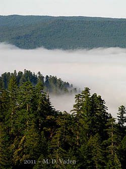
The image on the left is TTG, at the botttom of the first trail I mentioned. The image to the top right is upstream from Bridge Creek along Redwood Creek, but not quite as far upstream as the area in the header photograph. The bottom right photo shows the forest from the overlook at Bald Hills Road before you reach the gate. Redwood Creek is down under that fog, which sometimes gives way to blue sky: othertimes not.
If you add minor excursions to what I mentioned above, and stop to take photos, this should be occupy 2 days, maybe 3 days if you also spend some relaxation time soaking in the beauty in a few spots. If you don't get to the redwoods often, you could spend hours alone making sure you got some really well composed photographs.
Prairie Creek: Miners Ridge and James Irvine Trail
Another area: go to Prairie Creek redwoods off Highway 101 to the north, using Drury Scenic Parkway. There is a separate parking area for overnight camping, right next to where the rangers are based, across from the visitor center. And another excellent place to leave your vehicle overnight. It's right where the parks rangers are based.
A round trip of hiking is roughly 11 miles. Some people do this in one day. But its a long enough loop to add a generous hike for each of 2 days. A good way to handle this park when you are backpacking, is to just hike one other short trail in the park without packs in the morning, then go on the main adventure starting late morning. Then set up camp and enjoy. The next day, you can return near the visitor center, and add in one more short trail from near the Drury scenic parkway.
Backpacking these two parks will offer old-growth redwood, creeks, wildlife, the ocean, and an elk prairie in between. For maps, potential permits, trailhead locations and distances. ask the parks visitor centers.
You can also go to redwoodhikes.com to look at the maps there, to familiarize. But please don't send me questions about camping specifics. That's what the parks offices are for. The purpose of this page was just to offer a little extra that you may not read about elsewhere.